
Mission Statement: Explore the North section of England’s largest lake
Launch Point: Ferry Nab, Bowness-on-Windermere
Trail Introduction
This trails starts at Ferry Nab, Bowness and takes you on an anti- clockwise route North along the Eastern edge of Windermere all the way up to Waterhead in Ambleside, the Northern end of the lake. There are plenty of stops along the way to explore the North of the lake especially during our long summer days. Returning South you will sail along the Western edge and back to Bowness.
About the area:
Windermere formed as a ribbon lake around 13,000 years ago during the last major ice age. As the ice receded, it left Arctic char behind; consequently, anglers can still catch them in the lake today.
Windermere has 18 islands, with Belle Island as the largest, and it remains privately owned. Locals call many of the smaller islands “holme,” using the traditional word for island. In 1930, Alfred Wainwright made his first trip to the Lake District, arriving by train at Windermere. From the station, he climbed up to the viewpoint at Orrest Head, where the lake spread out before him.
“It was a moment of magic, a revelation so unexpected that I stood transfixed, unable to believe my eyes.”
That visit changed his life. He went on to create his famous Pictorial Guides to the Lakeland Fells, writing all seven books over 13 years. In them, he described 214 fells and illustrated each one with his distinctive hand-drawn sketches.
Today, these guides remain in print and continue to inspire a devoted following, with many walkers retracing Wainwright’s routes. In 2021, one record-breaking challenge saw all 214 peaks completed in under six days.
Interesting fact:
Reed beds provide essential resting places for birds throughout the year, but they are in decline. While work is underway to restore them, please avoid landing boats on shorelines with reed beds and do not drag boats through them. Clear markings identify these sensitive areas. Thank you for helping to protect them.
Water flows very slowly through Windermere; it takes around six months for a single drop of rain at the northern end to reach the southern end.
Round Trip Distance:
Approximately 10 miles. (8.5 Nautical miles )
Approximate Time that the Trail will take:
Approximately 4 hours.
OS Map or Chart: OS OL7
Trail Details
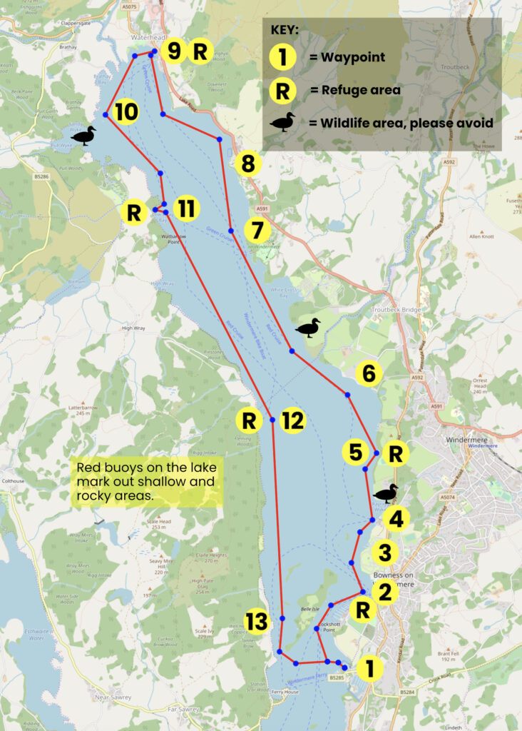
This map is for information use only, not for navigation.
- Launch from Ferry Nab and head north, keeping Belle Isle to your port side
- Sail past busy Bowness bay, or stop and explore via the public jetty ( 2 hour max )
- Leave the bay and continue north, keeping to the east side of the lake and watching out for the shallow areas around the small islands Hen Holme, Lady Holme & Rough Holme
- Stop off at the jetty museum for a visit
- Moor up to the Rayrigg public jetty and stop for lunch, explore the park or let the kids run off steam on the waterfront
- Continue north taking in the amazing scenery and passing Miller Ground Bay
- Stop at the jetty for the Brockhole café and adventure playground
- Sail past Low Wood Bay Resort & Spa, the Lake District’s first resort hotel
- Stop off at Waterhead (public jetty 2 hours max) for a stroll or some shopping
- Head south down towards Wray Castle
- Stop off at Wray Castle, the home of one of the founders of The National Trust (max stay 2 hours) – Be sure to moor up on the right-hand side of the Launch pontoon
- Sail on past Belle Grange Bay or moor up to Bark Barn public jetty (2 hours max) to explore
- On approach to Belle Isle, head between the island and the western shoreline. Red buoys will mark any known shallow areas
Trip Extensions:
Visit Stock Ghyll Force Waterfalls.
Windermere Jetty Museum
World of Beatrix Potter
Toilets:
The start/finish location, the Jetty museum, Rayrigg, Brockhole café and Waterhead.
Toilets What3Words:
Ferry Nab ///bogus.defected.doped
The Jetty Museum ///keepers.tinny.enhances
Rayrigg ///baths.thinking.caring
Brockhole cafe´ ///buns.clincher.rejected
Waterhead ///deluded.rash.informer
Useful information
The lake is always cold. Wetsuits are advised.
Red buoys on the lake mark out shallow areas and rocks.
Page Month Published:
March 2025
Updated April 2026