
Mission Statement: Follow in the footsteps of the Thames barges
Trail Introduction
This trail is an easy sail for those with a smallish dinghy (the local sailing club use dinghies of 12 ft or under) although it was used by 80 ft barges years ago. It is an easy sail especially in Easterly winds and in the summer the scenery is stunning with birds ranging from Herons to kingfishers may be seen on the saltings. The recommended tuning point is where Fenn Creek splits into two, known locally as The Winding Ways where the 80 ft barges were turned in the past.
About the Area:
The River Crouch sits at the southern end of the Dengie peninsular, the northern end being the River Blackwater. On the eastern edge you will find the Chapel of St Peter-on-the-Wall, a Grade 1 listed building which is among the oldest Christian churches in England. Built in 654 AD the chapel is still in weekly use today.
Fenn Creek nestles alongside the commuter town of South Woodham Ferrers. Close by Stow Maries you can find the first world war aerodrome which saw the birth of the Air Defence of Great Britain. The aerodrome played a key role in the Battle of Britain during WWI and it was here that No 37 Squadron transitioned from the Royal Flying Corps to the Royal Air Force. It continued in this role until Spring 1919.
Not far from here is RHS Hyde Hall which is located in one of the driest parts of the United Kingdom. Based at the top of a windswept hill, the garden is well know for its dry borders and is well worth a visit.
On the south side of the river towards its mouth can be found the UK’s largest coastal wetland recreation project at Wallasea Island. The project is designed to provide valuable coastal habitat as well as carbon sequestration and reducing flood risk.
Interesting fact:
To the north of South Woodham Ferrers is Bushy Hill. In later years the hill was known as Radar Hill as it was visually dominated by a radar testing site. Whilst still in use today the radar dish has been removed.
Round Trip Distance:
3.5 miles ( 3 Nautical miles )
Approximate Time that the Trail will take:
2 – 3 hours
OS Map or Chart:
OS 183 / Admiralty chart 3741 / Imray Y17
Trail Details
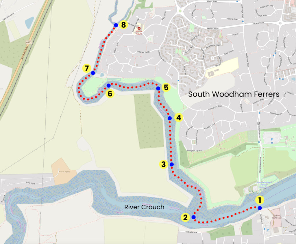
This map is for information use only, not for navigation.
Despite the trail being on protected waters, the sailing can be tricky with a winding path and shifty winds, great to practice your boat handling skills! It is ideally undertaken in an easterly breeze leaving 2-3 hour before high water when the tide will help you on your way up and on the way back.
- Leave the public slipway and turn left
- Head West up the River Crouch until Fenn Creek opens up on your starboard side, enter the Creek, passing the yellow racing mark W, and continue upstream
- Continue up stream, rounding several bends and a straight stretch
- Near the sluice gate watch out for wind-shifts due to the wind shadow from the nearby houses
- Approach Heartbreak Corner a long corner, aptly named for its contrary wind shifts
- Sail past the friendly Eyott Sailing Club
- Sail past Eyott Farm where, in the 1500s Thames Barges would load straw bound for London, returning with muck to spread on the fields
- Turn around here and head back to Hullbridge
Trip Extensions:
Visit Wallasea Island wild coast project https://www.rspb.org.uk/days-out/reserves/wallasea-island
Launch Point Lat and Long:
51°37’46.97″N – 0°36’48.80″E
Launch Point What3Words:
///plastic.blazers.thickened
Launch Information:
Ferry Road public slipway is free to launch. Best to 2 to 3 hours before high tide.
Tidal Information:
Hullbridge is subject to a normal semi-diurnal cycle (2 high and 2 low tides per 24 hours) with a tidal range of approximately 6m on springs and 4m on neaps
Best Tides:
lunchtime high tide = 12,13,14,
Towing Vehicle Parking:
Riverside Car Park is a free car park with single spaces accessed from Ferry Road, there is a height restriction of 2.2m
Towing vehicle Parking What3Words:
///thrashing.passage.bridge
Towing vehicle Parking Information:
Riverside Car Park is a free car park with single spaces accessed from Ferry Road, there is a height restriction of 2.2m
Trailer Parking:
Riverside Car Park is a free car park with single spaces accessed from Ferry Road, there is a height restriction of 2.2m
Trailer Parking What3Words:
///thrashing.passage.bridge
Trailer Parking Information:
Riverside Car Park is a free car park with single spaces accessed from Ferry Road, there is a height restriction of 2.2m
Toilets:
Yes
Toilets What3Words:
///allowable.rang.intro
Toilets Information:
Hullbridge Parish Council maintains toilets located at the car park entrance by the height barrier ( 2.2m height restriction )
Page Month Published:
October 2025
Dinghy Trail Sponsor: