
Mission Statement: Cross the Solent and enter a different world
Launch Location
Launch Point: Lymington
Trail Introduction:
This trail will take you from the bustle of Lymington in the heart of Hampshire’s New Forest across the Solent to the Isle of Wight and the beautiful tranquil haven of Newtown Creek. This is a route that takes in open water sailing
and also a spot of creek crawling at both ends of the route.
About the Area:
The Solent is one of the great sailing destinations of the world. This huge sheltered stretch of water was originally a river valley which flooded as water levels rose at the end of the Ice Age to form a channel between the Isle of Wight and the mainland which varies in width between 21⁄2 and 5 miles. This has provided excellent, relatively sheltered waters which proved ideal for sailing. As a result, the area became a hub of the relatively new and novel sport of yachting in the mid 19th century when the area was further popularised by the Royal Family who frequently passed the summer at Osborne House near Cowes.
Newtown Creek on the Isle of Wight side of this trail is a large natural harbour made up of several river estuaries. There are two main fingers to the estuary with the small hamlet of Newtown sitting between the two. The area has been designated as a nature reserve and is run by the National Trust. It is one of the most tranquil and undisturbed harbours in the Solent and has been designated as an Area of Outstanding Natural Beauty. It’s a twitchers delight and a wonderful place to explore by dinghy.
Lymington has a long history of smuggling and its most famous smuggler was Tom Johnstone who was born in the town in 1772. Johnstone was imprisoned a number of times but always escaped. In later days he became captain of a British naval revenue cutter, HMS Fox, pursuing the very men he had once worked alongside.
Safety Note
See the safety notices on the Lymington Launch Location page
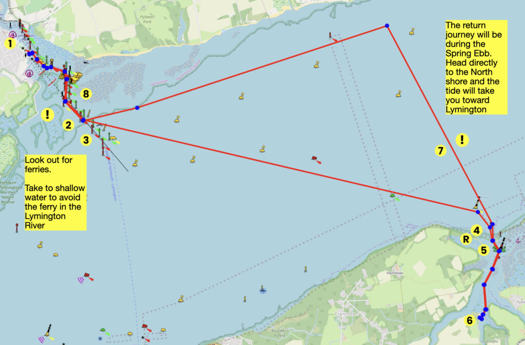
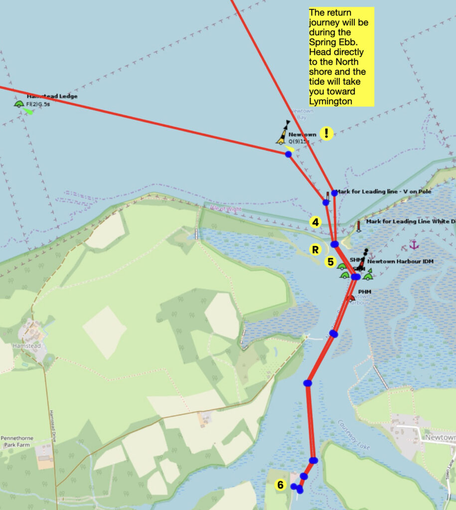
On the return journey the ebb will be flowing fast, and the greatest inconvenience on this adventure is to be swept past Lymington entrance by the tide. You need to be able to maintain 3 knots of speed, be that by sail or by additional propulsion, and aim directly at the North shore until in the relative shallows, so that the entrance can be judged and entered. The tide will ferry-glide you to close to the entrance.
Round Trip Distance:13Nm
in miles
Approximate Time that the Trail will take:6-8 hours including a leisurely lunch
In a Wayfarer or similar in F4 winds
OS Map or Chart:
Trail Details:
This map is for information use only, not for navigation.
- Head south after launching. Stick to the western bank of the river close to the edge of the river. Stay between the large yellow bouys and the pontoons to stay out of the main channel and avoid the large ferry
- As you reach the outer limits of the river, aim for the Jack in the Basket beacon. Be aware that this area can often get very hectic if there is a race going on
- Take a bearing of 103 degrees or ESE from the Jack in the Basket beacon to the entrance of Newtown Creek. Keep an eye out for the ferry
- Stop for a picnic here or if you’d prefer go into the creek and sail up to the pub.
- Head through the narrow entrance to Newtown Creek. A sure sign you are there is the sight of masts within. Once inside there are two good choices to land. If the wind has an Easterly component, sail into the harbour and turn immediately West and back on yourself to pull up on the windward shore of the sandy spit.
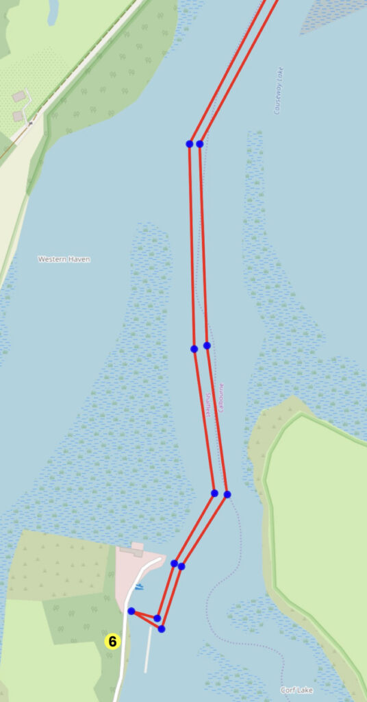
- If the wind has a westerly component, sail up to Shalfleet Quay, pull the boat up on the bank and walk down to the New Inn Pub for lunch.
- Head back to Lymington aiming for the Jack in the Basket beacon on a bearing of 244 degrees, but the tide is likely to be vigorously ebbing so to prevent being swept past the Lymington River, aim directly across the Solent and ferry-glide to the entrance.
- Thread your way back up river to Bath Road and recover.
Trip Extensions:
If you have lots of time before the high tide, sailing west from Lymington and in through one of the Keyhaven entrances and out of the other can be quite fun. This makes it a 19Nm daysail.
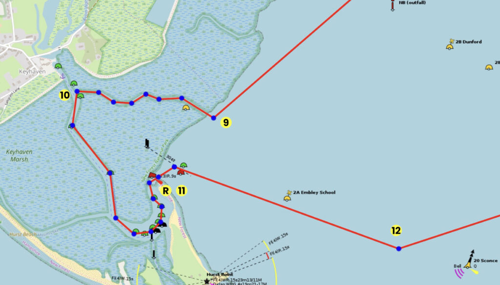
9. The Eastern entrance becomes obvious only when you get close to it
10. Turn South at the junction
11. The shingle spit is a lovely place to stop and admire the view. It’s safe on either side
12. If you are sailing this trail for the Spring stand between 13:00 and 15:00, you’ll come out of here with the Spring tide flood at it’s strongest. Head immediately for the centre of the tidal current and it will take you towards Newtown Creek.
Interesting Fact:
The tidal stream between the main entrance to Keyhaven and Hurst Point flows southerly for 11 out of every 12 hours.
Tidal Information:
This trail is best done on the Spring Tide, with the tidal stand from about 13:00 to 15:00, and the ebb tide is up to 3.4 knots, so ensure that you are not carried past the Lymington entrance.
Best Tides: Lunchtime high tide = 12,13,14,15
Page Month Published: March 2025
Dinghy Trail Sponsor: