
Mission Statement:
Discover the delights of the many beaches along this trail
Trail Introduction
The stunning Salcombe Estuary is just waiting to be explored. Enjoy your day discovering the beautiful shoreline and clear waters. Though the water can be busy at times there is so much to see, it is well worth the trip!
About the Area:
The Salcombe-Kingsbridge Estuary was originally a deep river valley that was inundated by sea level rise creating a wide expanse of water. With no river input the estuary is almost entirely a marine system which has brought about some rare and important habitats and species including reed beds, mudflats and eelgrass beds. Home to several species of crab, shellfish, otters and it is not uncommon to see dolphins, seals and basking sharks venturing into the estuary to feed. The estuary is an Area of Outstanding Natural Beauty, a Site of Special Scientific Interest as well as a local nature reserve and lies within the South Devon Heritage Coast. Originally a fishing and ship building port Salcombe developed as a holiday resort in the 1920’s. The first holiday home was built here in 1764. During the English civil war the town sided with the Royalists, you can see the ruins of Fort Charles. The estuary became an amphibious base for the US Navy during World War II. Their ships were part of of the Normandy Beach landings. Salcombe and the area around it suffered from a number of bombing raids during the war. In 2017 the Dart and Salcombe RNLI lifeboats supported the British Divers Marine Life Rescue Organisation to successfully free a Humpback whale caught up in fishing lines. Salcombe ice cream is very popular and is sold all over the world as faraway as New Zealand and Singapore! The estuary is a very popular venue for dinghy racing events and the estuary can be very busy and care should be taken. The tide is a significant factor in navigating around the estuary and can present challenges. We advise checking the Salcombe Harbour Guide for more information.
Round Trip Distance:
5 miles
Approximate Time that the Trail will take:
Approximately 4 hours
OS Map or Chart: OL20, Admiralty chart 28, Imray Y44
Trail Details
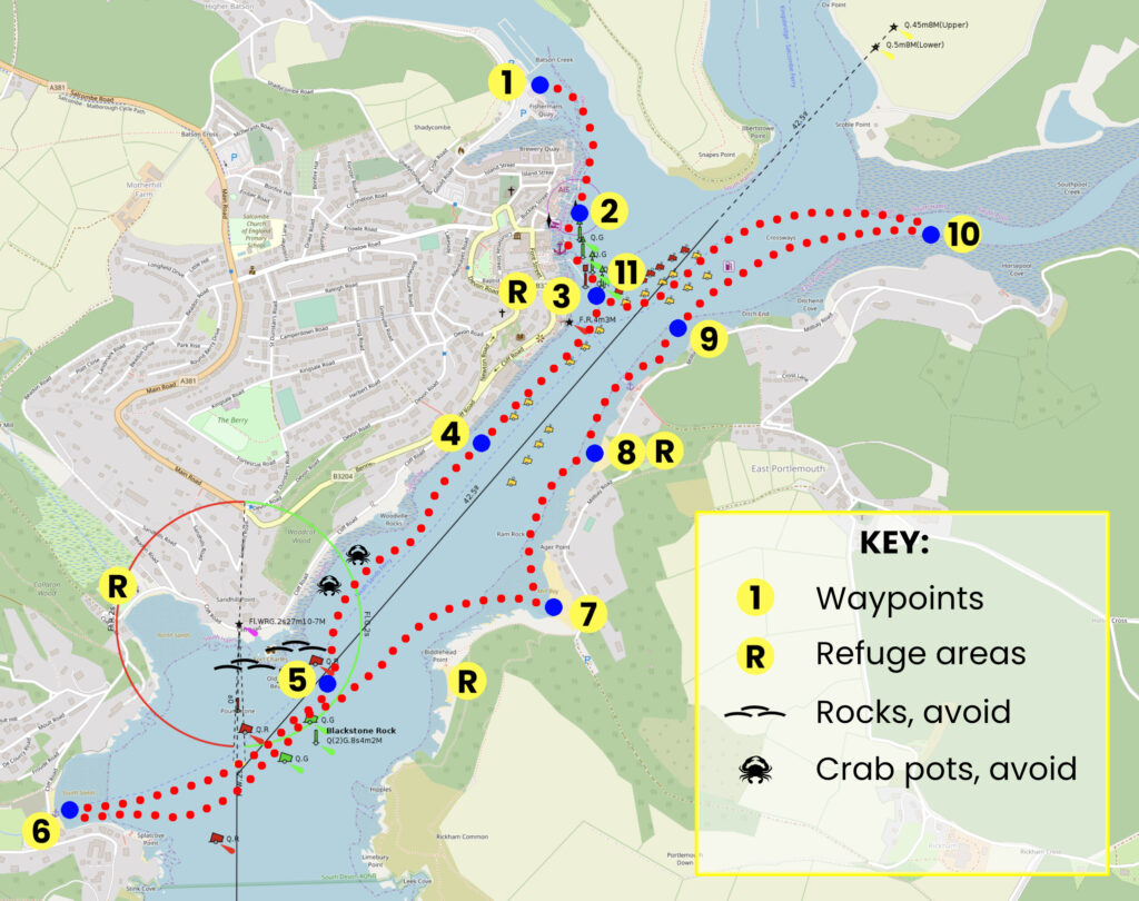
This map is for information use only, not for navigation.
- Head south down the creek, towards the lifeboat pontoon
- Sail past the privately owned Whitestrand pontoon. Beware that at low water the channel can be quite narrow
- Passing between the port and starboard lateral marks, head south east down the main estuary
- Enjoy the excellent sailing down this wide part of the estuary
- Leave the ruins of Fort Charles and North Sands to the west and head into South Sands
- Take a break for lunch at this lovely sandy beach that shelves gently. You can beach or anchor here
- Mill Bay is the perfect spot for a quick dip before heading home, make sure you get your landing permit from the Venus Café at the ferry steps
- Smalls Cove is another perfect swimming spot or wave to the swimmers as you sail past. Please note anchoring is prohibited here
- Stop off at Portlemouth Beach for an ice-cream from the café
- If you have time head up to Southpool Creek at high tide for some great sailing
- Head for home across the harbour back through port and starboard lateral marks marking the entrance to Batson Creek
Beware tides, undercurrents and swimmers when approaching beaches. The area by Salcombe Yacht Club can be busy with dinghy racing. During racing all non-racing traffic is requested to proceed to a race free lane on the town (west) side of the channel, marked by yellow buoys and a yellow cross at each end. Salcombe YC displays yellow flashing lights at this time from the Watch House. This is a busy harbour with lots to see and plenty to be aware of. We recommend this essential reading Salcombe Harbour Guide
Trip extensions:
Try some crabbing! Customs House Quay & Victoria Quay,, overlooking the lifeboat but stay off the pontoons.
Launch Point Lat and Long:
50°14’31.74″N – 3°46’4.26″W
Launch Point What3Words:
///squabbles.snake.prune
Launch Information:
Daily Harbour dues per metre of vessel are £1.97 – With an engine add 17p per horse power
The launch fee is included in the harbour dues fee
More information can be found here
Tidal Information:
See the yellow box above
Best Tides:
Comma Separated list of the HIGH TIDE times which are best for this dinghy cruise
For instance;
lunchtime high tide = 13,14,15
Towing Vehicle Parking:
Park at Batson Creek car park on Gould Road. There are two electric vehicle charging bays with 22Kw chargers.
Towing vehicle Parking: What3Words: ///flap.loom.shredding
Towing vehicle Parking Information:
Low season all-day parking (max 10 hours) £10
High season all-day parking £10 ( 2025 prices )
24 hours £13 ( not available in low season )
Overnight parking ( 6pm to 8am ) is free in low season and £3 in high season
More information can be found here
Trailer Parking:
Park at Batson Creek car park on Gould Road. Trailer will need to take up one car park space, fees apply.
Trailer Parking What3Words: ///flap.loom.shredding
Trailer Parking Information:
Low season all-day parking (max 10 hours) £10
High season all-day parking £10 ( 2025 prices )
24 hours £13 ( not available in low season )
Overnight parking ( 6pm to 8am ) is free in low season and £3 in high season
More information can be found here
Toilets:
Yes
Toilets What3Words: ///limit.money.influence
Toilets Information:
Public toilets ( 24hr ) are also on Gould Road
Page Month Published: October 2025
Dinghy Trail Sponsor: