
This trail is a work in progress. The map currently shows a trail starting and finishing at Ramsholt, however for reasons explained below, we are going to have to adapt the trail to start somewhere else. I have re-written the trail to start and finish at Waldringfield, but I have not tested it and I do not know when I am going to be able to get back there to do that. If anyone else is planning on cruising the Deben, please feel free to add to or adapt what I’ve written, or use anything I’ve written to copy and paste into your own cruise guide.
Due to the re-write, the numbers on the map do not correspond to the numbers in the written guide.
Mission Statement:
Explore as much of the River Deben as you like
Trail Introduction:
The River Deben is one of the many broad, tidal rivers which make this part of East Anglia a great dinghy cruising area. It is beautiful and interesting, and there are several different ways to explore it. Which one you choose might depend on how much time you have, the tide times on the day of your cruise, what kind of boat you will sail, and how brave you feel!
About the Area:
You could start your cruise from Felixstowe Ferry, Waldringfield or Woodbridge.
As with any tidal river, you have to keep an eye on what the tide is doing, plus a lookout for moored yachts, traffic and other potential hazards, and although this is one of the narrower and more sheltered stretches of the tidal Suffolk rivers, it still has expanses of water easily large enough to get quite choppy if a fresh breeze blows against the current. But essentially this is a gentle and friendly river, and gave us an idyllic day out last May.
This is the river that the 90ft Anglo Saxon ship sailed up before it was dragged overland to the famous burial mounds at Sutton Hoo. The National Trust site there is worth a visit, and so is the Longshed in Woodbridge where a full-scale replica of that ship is currently being built. It is hoped it will be ready for launching in spring 2025. Also, keep an eye out for two of Arthur Ransome’s old yachts – Nancy Blackett and Selina King – both of which have their homes on the Suffolk rivers and are often sailed on the Deben.
We sailed our Westray 16, Tarka, from Ramsholt most of the way to Woodbridge and back in May 2024, and hope to return in 2025 and make it all the way next time!
Grading: We need to agree the definition, the grading will go here
Round Trip Distance:
10 nautical miles
Approximate Time that the Trail will take:
In a Wayfarer or similar in F4 winds
4-6 hours
OS Map or Chart:
OS Explorer 197
Trail Details:
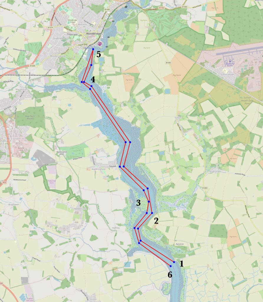
Step by Step description of the trail, refuge points, including the image of the map of the trail
- Launch at Waldringfield. We started our cruise from Ramsholt, but although the very friendly and helpful harbourmaster there was happy to allow permission for one dinghy to launch there, he was understandably hesitant to endorse a published RYA dinghy trail which begins and ends at the Ramsholt slipway – the purpose of which is to allow moorings holders to launch tenders to access their yachts. I have since scouted out Waldringfield, but not tested it with a boat. The harbourmaster at Waldringfield was happy with the idea of there being a start and finish point for an RYA dinghy cruise, but launching and recovery there is not straightforward. My understanding is that the slipway is useable roughly one hour either side of high water. Outside of those times, there may be some beach between the hard surface and the water. The East Coast Rivers Cruising Companion states that ‘clean landing from a dinghy is possible along the sandy shingle foreshore at almost any time’. I expect it would be fine for lightweight dinghies, but heavier ones might struggle. It might be easy enough to roll a heavyish dinghy down the beach to launch, but very difficult to haul it up for recovery. Therefore, if I were planning to use Waldringfield as a start/finish point, I would aim to return to it no more than one hour after high water, and launch about three to four hours before high water to have a four to five hour cruise. If you do decide to ask contact the harbourmaster at Ramsholt, be advised that the slipway there is very narrow. There is also a shingle hard between the slipway and the quay. The water reaches the hard at approximately half tide. Below the hard is soft mud. We made a determined attempt to launch Tarka about half an hour before the water reached the hard, and managed to drive the trailer about a yard through the mud before it got completely stuck. We spent a pleasant twenty minutes waiting until the water rose high enough to float Tarka off the trailer, and then managed to find some strong and willing volunteers to help us haul the trailer out of the mud again.
- Troublesome Reach. We did not discover why this stretch of the river has such an ominous name. However, it was the point at which we decided to turn around. We could have got further, the tide was still flooding, but we had an early-ish dinner booking at the Ramsholt Arms! It was a pity to be able to see fascinating harbour of Woodbridge in the distance, but know we would have to leave exploring it for another day.
- Woodbridge. Can you get all the way to Woodbridge? There’s plenty to look at in addition to the Sutton Hoo replica ship, such as old sailing barges and the only working tide mill still in operation on the East Coast.
- Recovery at Waldringfield.
Trip Extensions:
- How far up river can you get?
- A short way downstream from Waldringfield is The Rocks, a pleasant shingle beach and anchorage. We saw several dinghies pulled up there when we sailed past, with their sailors enjoying a rest on the beach.
- How far downstream can you get? For a really long cruise, you could launch from Waldringfield on the ebb tide, and sail down towards the river entrance, before sailing back up again with the flood. We have not explored downstream of Ramsholt yet.
Extra info:
Before coming here, you may like to watch The Dig, which is based on the story of the excavation of the Sutton Hoo burial ground, and possibly Yesterday, a fun story about a musician who suddenly discovers that nobody else has ever heard of the Beatles, scenes from which were shot at the Ramsholt Arms.
Some relevant links:
My YouTube video featuring our day on the River Deben https://www.youtube.com/watch?v=56bLD9Jpc5o
The studio of sailing artist Claudia Myatt in Waldringfield https://claudiamyatt.co.uk
The Longshed, Woodbridge https://saxonship.org/the-project/the-longshed/
The Ramsholt Arms pub https://www.theramsholtarms.com
Waldringfield Sailing Club https://waldringfieldsc.com
Launch Point Lat and Long: N52,01.370 E001.21.670
Launch Point What3Words: warp.seasonal.indulgent
Launch Information:
Costs to launch: Free/donation
Tidal Information:
A spring tide will give you more water to sail on and faster currents to ride up and down the river. Spring high tides in this area are around lunchtime/early afternoon.
If you have a boat small enough to be able to use the slipway at Ramsholt then you have the freedom to launch and recover at any state of tide. If you need to use the hard then you will need to wait until about half tide to launch. Seeing what time the water reaches the hard on the flood tide will help you judge what time you are able to recover until, and I’d advise building in some margin for error! Hide tide in Woodbridge is between 30 and 50 minutes later than high tide at the river entrance (Felixstowe Ferry).
Best Tides: 12, 13, 14
Towing Vehicle Parking: Ramsholt Arms or Ramsholt public car park
Towing vehicle Parking: What3Words: mingles.reported.snowboard or leaned.cork.kilt
Towing vehicle Parking Information:
Trailer Parking:
Trailer can probably be left in the dinghy park – check with harbourmaster if possible.
Trailer Parking What3Words: drifter.submerged.extremes
Trailer Parking Information:
Costs and things to know
Toilets:
Ramsholt Arms
Toilets What3Words: valuables.swooned.newlyweds
Toilets Information:
Page Month Published: March 2025
Dinghy Trail Sponsor: