
Mission Statement: Follow in Lord Admiral Nelson’s footsteps.
Trail Introduction:
This trail starts on Barton Broad, the second largest of the Norfolk Broads, covering approximately 170 acres. Not only is it a great place to sail, but the River Ant runs through the Broad, and there are several possible extensions to the trail (alternative means of propulsion required), which will put you amongst the nature of the Norfolk Broads.
About the Area:
Barton Broad was dug out in the Middle Ages for peat extraction, and was purchased by the Norfolk Wildlife Trust in 1945. Situated in an unspoilt, rural area, and the Broad has recently undergone a major environmental restoration project, leading to very clear water and a real haven for wildlife. It’s a great place for spotting otters, kingfishers and much more.
The Norfolk Punt, which can be found racing on Barton Broad, was derived from flat bottomed gun punts which roamed the Broads in the mid to late 19th Century. In order to get to their hunting grounds more efficienty using the wind the punters developed their punts to carry a basic mast and sail. Todays punts, at 22 ft long with 22 meters of sail and no maximum spinnaker size or minimum weight make for exciting racing dinghies.
A short distance away you will find Toad Hole Cottage Museum (open in the summer only) which gives visitors an interesting insight into the life of a marshman.
Interesting Fact: Lord Admiral Nelson was born nearby at Burnham Thorpe and was baptised at All Saints Church, which his father was rector of at the time.
Nelson joined the Navy aged 12 having had sailing lessons on Barton Broad.
The church has many historical artifacts including the font where Nelson was baptised from, the altar, lectern and rood screen made from timbers of HMS Victory along with flags from HMS Nelson and HMS Indomitable at the Battle of Jutland. The church has the unique right to fly the white ensign from its tower.
Round Trip Distance: 7.5 Miles (or 4 miles if not entering River Ant)
Approximate Time that the Trail will take: 3 hours (full trail)
OS Map or Chart: OS Map OL40
Trail Details:
This map is for information use only, not for navigation.
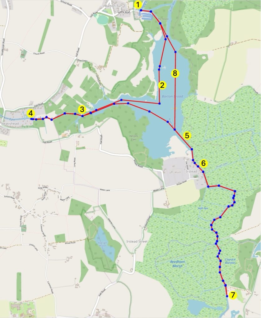
1 Launch from Cox’s Boatyard and follow the River Ant to join up with the Broad
2 Sail past the floating pontoons of the Norfolk Punt Club, and the ‘Arc’ belonging to the charity The Nancy Oldfield Trust
3 On the starboard side is Limekiln Dyke, a picturesque area which leads to Gaye’s Staithe, a popular mooring spot, close to the Barton Broad Boardwalk. Recently restored is a haven for wildlife on the Broad. At the end is Turkey Broad (not accessible to sailing craft). The next part of the trail is narrow, alternative means of propulsion is required.
4 Further along is Neatishead Staithe, an ideal spot for visiting the small village of Neatishead, with a shop and pub.
5 You can now travel down the River Ant but you may require an alternative means of propulsion.
6 Make your way through The Shoals, and leave the Broad, continuing on to Irstead Staithe, where you find a church and a favourite spot for kingfishers.
7 Pass by a couple of derelict windmills, and come to How Hill, where there are plenty of free moorings (busy in the summer). See if you can spot a traditional Broads Wherry moored here, the Secret Garden at How Hill, and Toad Hole Cottage – a thatched Marshman’s Cottage.
8 Retracing your route will take you back to Barton Broad where you can return to your starting point. Alternatively, you can enjoy a sail around the Broad.
To get an idea of the area before you go check out this video from the Sailing Skismo YT Channel.
Trip Extensions:
Visit the birthplace of Nelson at Burnham Thorpe
Feel Like A Challenge?
Take part in the Barton Regatta over the August Bank Holiday
Launch Point Lat and Long: 52.7478118938192, 1.4918595732495292
Launch Point What3Words: https://what3words.com/flotation.homelands.punctual
Launch Information:
There is a slipway at Cox’s Boatyard, with trailer and car parking. Launch and parking fee is payable (as of March 2025, this is £5). Contact Cox’s Boatyard for further information.
The closest shop is in Neatishead, a 10-minute drive away.
Further details about Cox’s Boatyard: https://coxsboatyard.co.uk/contact-us/
A Broads Authority toll is required to use a boat on any part of the Norfolk Broads. A comprehensive guide to boating on the Broads, as well as online toll applications, may be found at https://www.broads-authority.gov.uk/
Tidal Information:
Barton Broad is slightly tidal, although the water level only varies by about 15cm (6 inches).
Best Tides:
Not applicable on Barton Broad.
Towing Vehicle Parking:
Cox’s Boatyard has onsite parking for cars and trailers. This is included in the launch fee.
Towing Vehicle Parking What3Words: https://what3words.com/flotation.homelands.punctual
Trailer Parking: Same place as towing vehicle parking (within Cox’s Boatyard).
Toilets: Onsite at Cox’s Boatyard. Cox’s Boatyard has a toilet and shower block open; Showers require a token, available from the office.
Page Month Published: September 2025
Dinghy Trail Sponsor: