
Mission Statement: Explore this easily accessible island gem
Trail Introduction
This trail takes you clockwise around the beautiful island of Great Cumbrae on Scotland’s west coast. Discover the stunning sea-life and explore the myriad of beautiful beaches around its coastline where you can stop and have lunch as well as some great opportunities to spot porpoises, basking sharks and lion’s mane jelly fish.
About the Area
The Battle of Largs took place in 1263 between Norway and Scotland. A fleet of 160 Viking vessels moored off the Cumbraes some of which broke loose in a storm, in trying to salvage their vessels a fierce battle ensued.
Millport is home to Britain’s smallest cathedral the Cathedral of the Isles and Garrison House which was used as accommodation for the Officers and Captain of the Royal George, a revenue sailing ship who played a key role pursuing smugglers on The Clyde.
There is an aquarium at FSC Millport where you can get up close and see the local marine life.
The lion’s mane jelly fish is one of the largest known species of jellyfish and can be found in the waters around Cumbrae from May to September. They can grow up to two meters wide. Be careful of them as they can give a nasty sting.
Basking sharks return to Scottish waters from the end of April, feeding on the rich plankton until autumn. They are sometimes spotted in the waters around Cumbrae so keep your eyes peeled.
Porpoises are regularly found in the waters aroud Cumbrae. Smaller than dolphins they can often be seen playing in the waves.
Why not finish the day with a trip to Nardini’s ice cream parlour. Opened in 1935 the parlour is based in a stunning Art Deco building on Largs seafront and with over 32 varieties of ice cream there is a flavour for everyone.
Interesting fact: Legend has it that in AD 710 St Mirin arrived in Cumbrae and rid the island of snakes. The Cathedral of the Isles is believed to have been built on the site where he preached. To this day Cumbrae remains snake free.
Round Trip Distance: 8 miles
Approximate Time that the Trail will take: 4 Hours in a Wayfarer or similar in F4 winds
OS Map or Chart: OS Explorer 341
Admiralty Charts 2491 or 1907
Trail Details
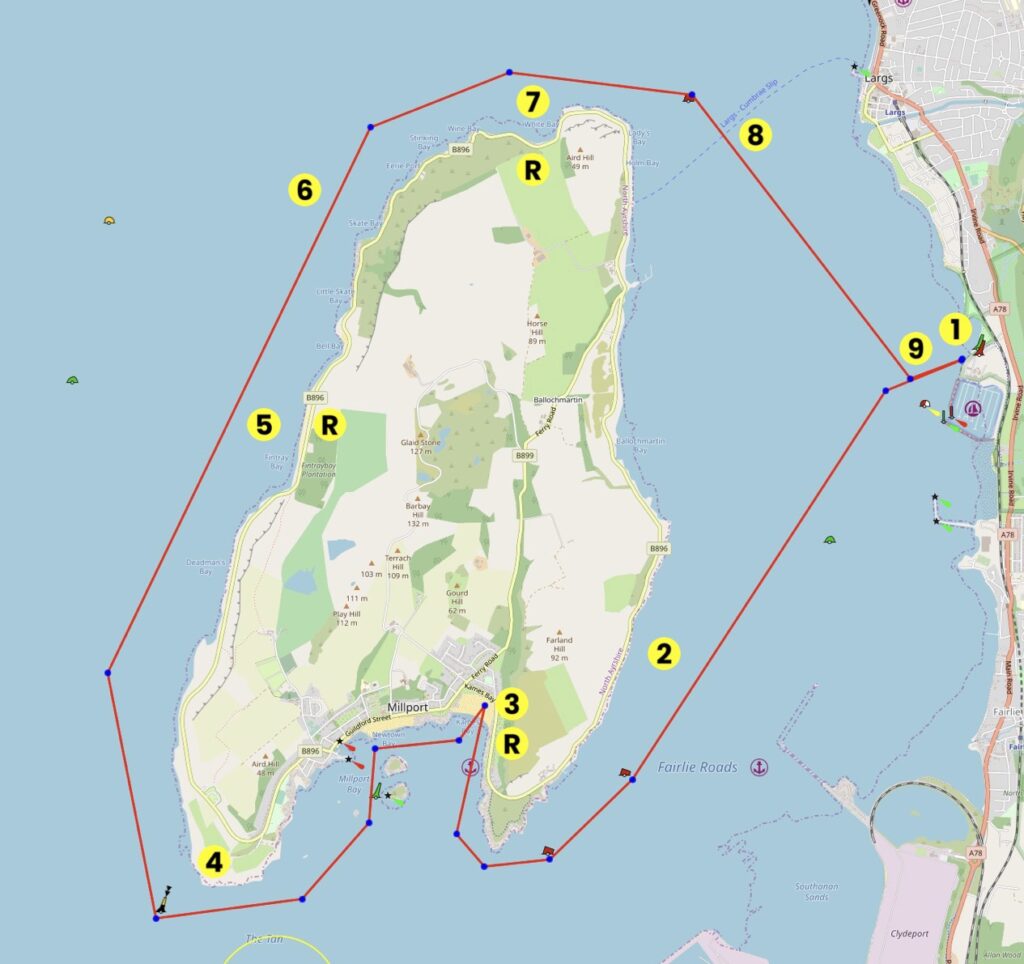
This map is for information use only, not for navigation.
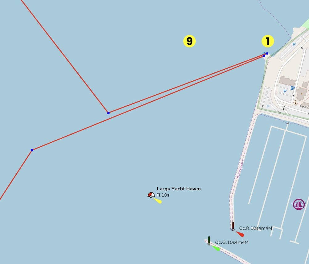
- Launch from the public slipway just before Largs Yacht Haven and head straight across the Largs Channel to Ballochmartin Bay on Cumbrae.
- Once you reach the island, sail south following the shoreline. You will pass the Hunterston Jetty on the mainland where bulk carriers used to load up with coal and ore.
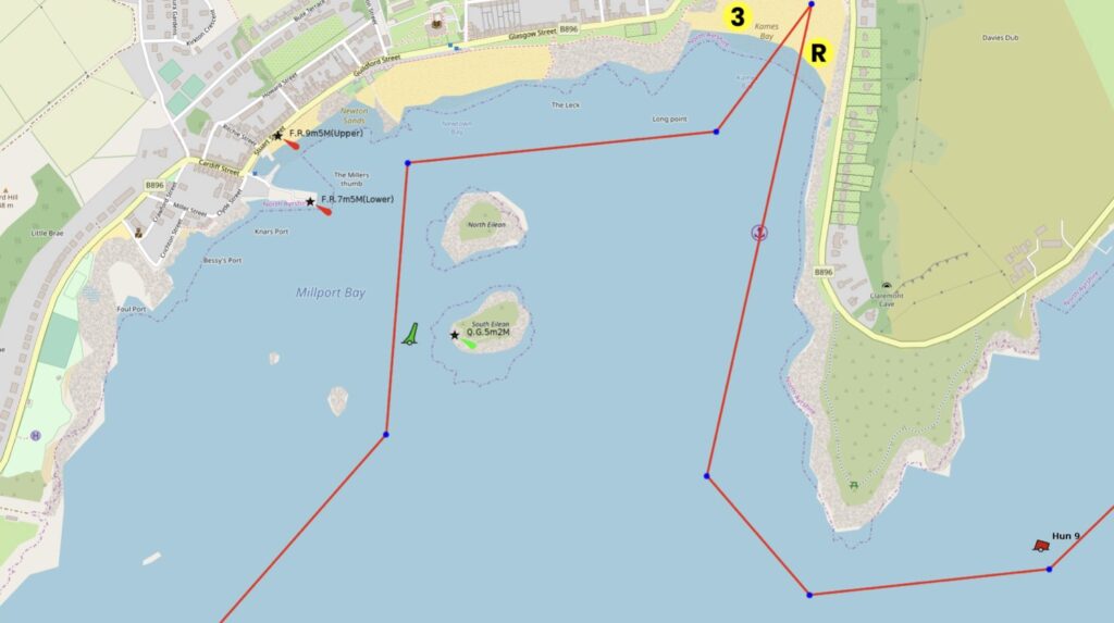
- On passing the south peninsular point, the waters open into Millport Bay. There is safe landing at the head of the bay at Millport and sandy beaches where you can stop for lunch.
- On leaving Millport see if you can see the painted Crocodile Rock before heading south, then west past then southern peninsular.
- Start your journey north past Deadman’s Bay and into Fintry Bay. There is a sandy beach here where you can stop for tea and cake at the High Tide Café (& WC’s).
- Keep heading north and watch out for Harbour Porpoises along the way.
- At the top if the island you will find White Bay, a great place to pause and take breath before making the crossing back.
- Once past the top of the island take a transit of the Largs Pencil Monument and make your way across the Largs Channel. When crossing beware of the Largs ferry which docks on the north east corner of Cumbrae.
- As you approach the monument from the north take care of the rocks as you approach the public slipway.
Safety Notes:
At 8, keep a good lookout for the Largs ferry which docks on the north eastern corner of the island
At 9, avoid rocks on the northern approach to the landing point at Largs.
Trip Extensions
Why not hire a bike and cycle around the island? millport.org/directory/cycling-around-cumbrae
Largs Regatta Festival largsregattafestival.com
Launch Point Lat and Long:
55.776605345507676,
-4.860028497560413
Launch Point What3Words: W3W: catch.prominent.trickled
Launch Information: Use the Public Slipway and Largs Yacht Harbour.
Free launch and car parking Greenock, KA30 8EZ
Tidal Information: Not yet gathered.
Best Tides:
Towing Vehicle Parking:
How and where to park the towing vehicle
Toilets: 8 Rockland Park, Largs KA30 8HB
Toilets What3Words:///dodging.costly.sardine
Toilets Information: Council operated toilets
Page Month Published: March 25
Dinghy Trail Sponsor: