
Mission Statement: A trip to the Crown and Anchor Pub
Trail Introduction
Dell Quay is at the end of the North Eastern reach of the beautiful Chichester Harbour. When the tide is out, it is a mud bound haven for wading birds but is transformed to a sparkling expanse of water when the tide arrives. The sailing club turns out and there is an explosion of boating activity. On sunny days there will be multiple small craft anchored up on the narrow gravel hard in front of the Crown and Anchor. This is a trip best accomplished with a High Tide time of between 12.00 and 15.00. Keep an eye on your anchored dinghy from the outside seating at the Pub.
Round Trip Distance:5.4 miles
Approximate Time that the Trail will take: 2 hours
OS Map or Chart: Y33 LANGSTONE & CHICHESTER HARBOURS (IMRAY CHART)
Trail Details
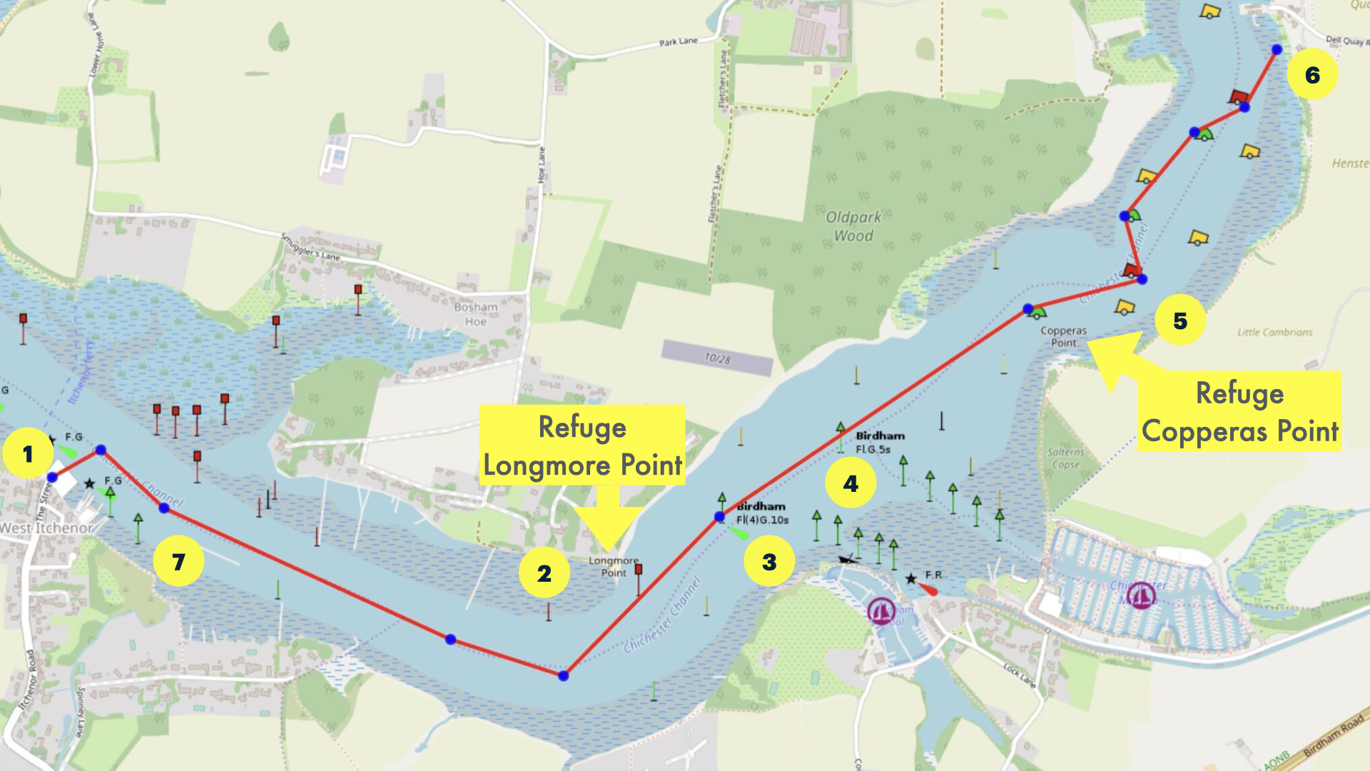
This map is for information use only, not for navigation.
1. Launch from Itchenor Hard on a rising tide and head ESE being careful to avoid the multiple moored yachts.
2. With Longmore Point (Bosham Hoe) to port the channel turns North East.
3. Pass Birdham Pool to Starboard
4. Pass Chichester Marina to Starboard
5. Be sure not to stray too far from the buoyed channel which swings starboard then to port and starboard again beyond Copperas Point. Your destination is visible ahead.
6. Land at the gravel hard in front of the Crown and Anchor and enjoy the refreshments available at the pub.
7. Leave on the falling tide and retrace your steps back to Itchenor. Be careful to stay over to the south of the channel as you approach Itchenor so as not to get swept past by the fast ebbing tide.
There are two refuge points on this trail – Longmore Point is a shingle spit on the North side of the channel, and Copperas Point is a shingle spit on the South side of the channel. If you arrive too early for the tide up to Dell Quay, stopping at Copperas Point is a lovely place to wait with your dinghy at anchor, and watch the activity in the harbour.
Dell Quay Sailing Club
Visitors are welcome to Dell Quay Sailing Club at weekends when racing is on. You must let them know that you plan to visit them in advance. Ask them using this form. The best timing is to arrive on the flood tide as their racing fleet departs for racing, and leave before their racing fleet returns.
(Checked for accuracy December 2024)
Trip Extensions: If there is sufficient wind to overcome the ebbing tide, sail past Itchenor on the return trip, and creep up the side of the channel against the ebb tide to Bosham for an ice-cream.
Tidal Information: The tide takes 7 hours to flood and 5 hours to ebb, so the streams are faster on the ebb than the flood.
This trail is best accomplished with high water between 1200 and 1500. The tides along this channel are very strong. Be aware that during the summer the entrance to Chicheter Marina can be busy.
Please respect the waders and wildfowl who live along the muddy shoreline. Share the Shoreline birdaware.org
Best Tides:11,12,13,14
Toilets What3Words: See Itchenor Launch Location
Crown and Anchor Public House https://w3w.co/winter.workbench.retrain
Dinghy Trail Sponsor: This dinghy trail was initially supplied by a member of the South region of the Dinghy Cruising Association, The friendly club with a sense of adventure. For all sailors who use boats for more than just racing.
Page Month Updated: November 2024