
Mission Statement: Explore the beauty and wildlife of this AONB
Trail Introduction
One of the busiest areas for sailing on the south coast, there are plenty of racing dinghies and moorings to see and navigate round as well as beautiful wildlife. This trail is best on a day with a low tide between noon and 16:00 so that you dry out nicely at East Head, and have the tide with you for the return. Pack your picnic and hop on board for a memorable days sailing!
About the Area:
This trail takes you on a short trip through part of Chichester Harbour which is a Site of Specific Scientific Interest and an Area of Outstanding Natural Beauty.
Itchenor’s main industry is shipbuilding and there was a prominent shipyard in the village during the Napoleonic Wars. In 1800, Transit, a 101 ft long four masted schooner was built on the spot that Itchenor Shipyard occupies today.
East Head is one of the fastest moving sand and shingle spits in the United Kingdom and is owned by the National Trust who play an important role in its management. It’s very f ragile environment is one of the last surviving pieces of natural coastline in West Sussex. The point that the dune connects to the land is known as ‘The Hinge’ and is currently under threat from erosion. An adaptive management strategy has been put in place to take steps to achieve an equilibrium between the sea and the land to avoid a breach and maintain public access. It is an important breeding placed for ringed plover who nest on the ground and are easy to step on due to their camouflage against the shingle.
Whilst on the trail you will pass the marshes and wetlands which are of significant international importance and are a Special Protected Area for wild birds. If you are lucky you may even see some seals as you approach East Head.
There is a cafe on East Head as you approach West Wittering beach – it’s about a 1.5 mile walking round trip.
Find out more about Chichester Harbour: conservancy.co.uk
Round Trip Distance: About 6 miles
Approximate Time that the Trail will take: 3 hours with a relaxing lunchbreak
OS Map or Chart: OL8 Admiralty
Trail Details
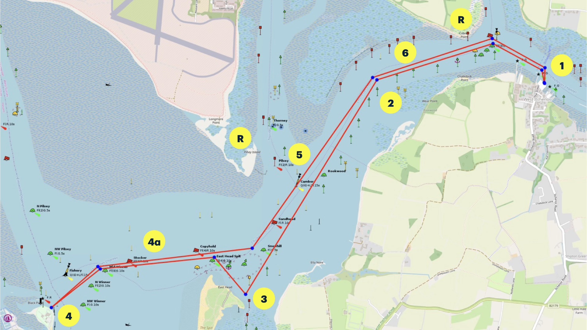
This map is for information use only, not for navigation.
1 Launch from the public slipway and, head west through the moorings. Sail past the channnel to the north which leads to Bosham. Continue to sail west
2 At the starboard hand ‘Chalkdock’ buoy turn south-west. East Head is ahead of you
3 There are several landing areas along East Head, however Snowhill Creek, is a sheltered spot in most conditions. The water goes out along way – make sure you can still get your boat back to the water
4 If the conditions are right, why not pop over to Hayling Island Sailing Club where you can get a an ice cream or snack from theirgalley on the ground floor
4a.Beware the strength of current, particularly on a falling tide
5 Head back upstream sailing past the the entrance to the Thorney Channel on the north shore keeping clear of any racing dinghies
6 Sail past the marshes back towards Itchenor
Refuges:
Cobnor Point has a rocky foreshore at all states of the tide.
Pilsey Island has a sandy foreshore at all states of the tide. Do not walk above Mean High Water Springs as it is contaminated MOD land.
Trip Extensions: From Hayling Island a quick trip out of the
Launch information, Car Parking, Trailer Parking – see Itchenor to Dell Quay
Tidal Information:
This is a good cruise for an ebb tide, with low tide between noon and 15:00, which will make this cruise always a neap tide.
Best Tides:
High tide = 5,6,7,8
Page Month Published: 11/24
Dinghy Trail Sponsor: Cody Sailing Club