
Name of the Dinghy Trail
Mission Statement: Visit a spectacular Isle of Wight location from the mainland by dinghy
Trail Introduction
This is an adventurous dinghy trail which only works with a specific tide and a specific wind direction and strength, so often it’s planned and then the wind does not cooperate.
When the conditions are perfect, this is a beautiful location to visit, with an extension of the main cruise out towards the West beyond the Needles.
Interesting facts Alum Bay is famous for the coloured sands in the rocks above the destination beach, and is a tourist attraction on the island.
Safety
Alum Bay is an exposed beach, and if there is any swell it’s not safe to land. Approaching this beach on a Southerly or South Westerly wind is safest, and on a day when there is likely to be no swell. Be prepared to not land on the Alum Bay or Totland beaches, and make this adventure one of looking and not landing. The refuge at Hurst is a good place to stop at if there is a swell.
Round Trip Distance:
11 miles
Approximate Time that the Trail will take:
In a Wayfarer or similar in F4 winds, about 6 hours with half an hour at Totland and an hour at Alum Bay.
OS Map or Chart:
Trail Details
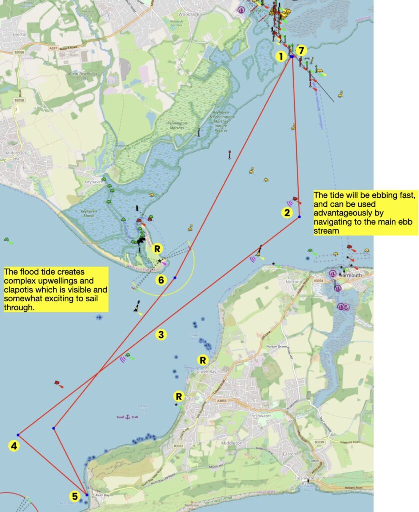
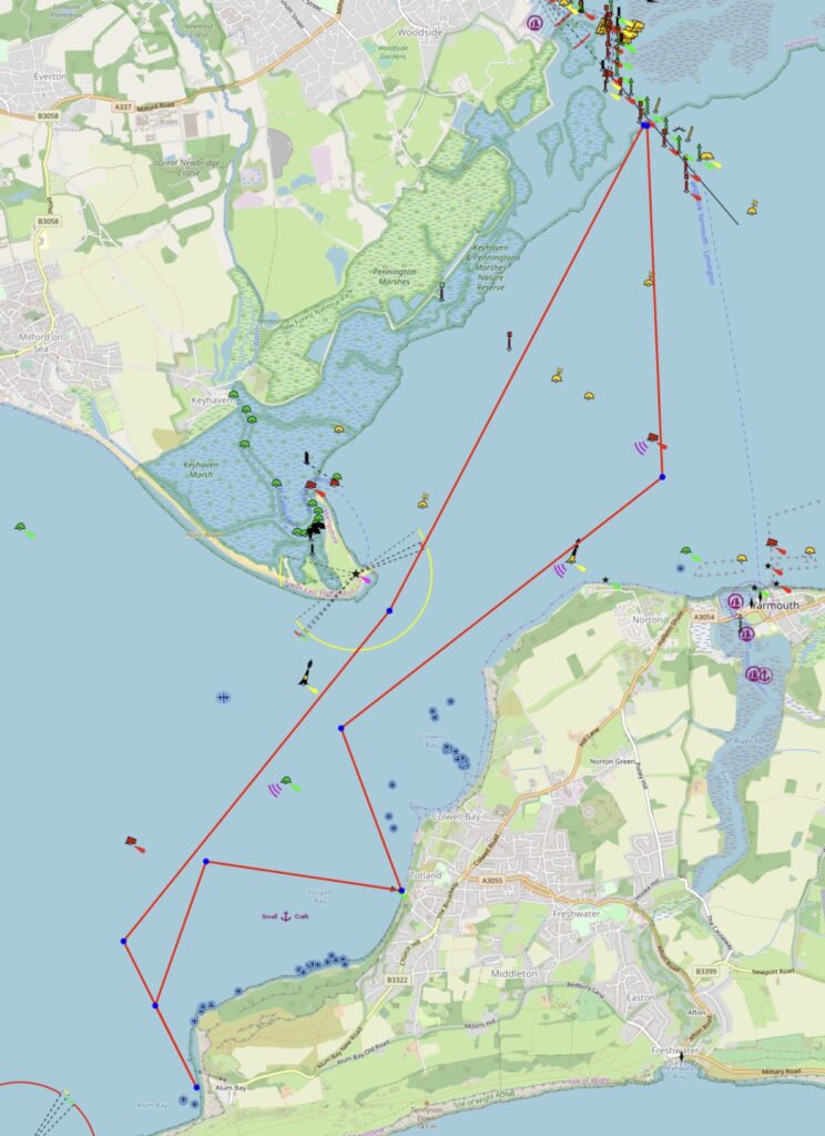
This map is for information use only, not for navigation.
- Assuming that you have launched from Lymington and have arrived at the entrance to the Solent, the direction to go should be obvious – between Hurst Point and the Isle of Wight
- Assuming that you are doing this on an ebb tide with a low water about 13:00 to 14:00 and you are leaving about 10am, there is a strong ebb tidal stream pouring out of the Easter Solent – so aim South and once beyond the Port Hand deep water mark, follow the deep water channel as the tide whisks you West
- Stay in the deep water channel, because there is a huge tidal circulation in Colwyn Bay which will add 20 minutes to your journey if you get into it.
- When the beach at Alum Bay is visible, turn towards the destination.
- There are three distinct areas of the beach, the most Northerly looks like a seductive place to stop, but just under the low tide waters are huge round stones. Just to the South of the cable-car is the best place as it’s a nice sloping beach, and beware that someone has dumped disused cable car cables under the low tide, so ensure that your anchor has a tripping line if you are planning to kedge in, otherwise you may lose your anchor. To the very South of the beach under the cliffs is rocky and slippery. Stay here on anchor or with the boat pulled up for an easy hour. When you are ready to return, sail out to the main channel.
- The flood waters create complex upwellings and little whirlpools and waters which appear to clap together, as well as areas of glassy smooth surface. Aim for the Lymington Entrance.
- Arrive at the river entrance and follow the information for returning up-river
Refuge locations are
- Colwyn Bay where there is a public slipway
- Totland where there is a sandy beach
- Hurst Point on the easterly side tucked in by the Lighthouse. If you are a member of English Heritage remember to bring your membership card as you can then get into the Cafe at Hurst Castle, and buy everyone in your fleet a hot beverage.
Trip Extensions:
If you time this right, and leave the beach at Alum Bay about an hour before low water, a completely pointless and fun adventure is to sail up to and past the Needles, and then head West. At some point the tide will change direction, and then you change direction and head back to Lymington. The flood tide will always arrive, and it’s a low-risk activity to take the last of the ebb, see how far you get and experience the change in the tide. Be mindful of the sea state if you do this, as there can be a 60cm high step in the height of the sea as the ebb arrives at, and is overwhelmed by the flood, which a dinghy must keep away from. As soon as the tide turns, the step melts away.
Tidal Information:
It is best to pick a day when the low tide is between 13:00 and 14:00 because the gap between Hurst Point and the Isle of Wight is a “tidal gate” and we sail with the Ebb on the way out, and with the Flood on the way back. The tide is very strong in both directions.
Best Tides:
Comma Separated list of the HIGH TIDE times or LOW TIDE times which are best for this dinghy cruise
lunchtime LOW TIDE = 13, 14
Toilets:
There are no toilets (that I know of) at Alum Bay.
To access public toilets, stop on the way there or on the way back at Totland, landing by the root of the pier on the East side, where there is a sandy beach to pull up on or anchor. There’s a nice cafe a short walk along the coast road. https://www.waterfrontiow.com
This map is for information use only, not for navigation.
Page Month Published: December 2026
Dinghy Trail Sponsor: Cody SC