
Mission Statement: Explore one of the most stunning & challenging passages
Trail Introduction
A great opportunity to explore one of the most stunning and challenging dinghy cruising areas around. This narrow strait needs to be treated with respect. Indeed, no less than Lord Nelson stated that if you could sail around Anglesey, you could sail around the world! Nevertheless, the rewards for those who accept the challenge are great, with a selection of beautiful ports to visit all with the wild and beautiful mountains of Snowdonia as a backdrop.
About the Area:
The Menai Straits is the narrow stretch of water that separates mainland Wales from the Isle of Anglesey. This 16 mile long strip of highly tidal water is as narrow as 500m in parts and indeed it’s very name alludes to this, for Menai comes from the Welsh main-aw meaning narrow. There are two bridges that connect Anglesey to the mainland and they both complement the dramatic nature of the strait which at points feels little more than a gorge – albeit one that reasonably large ships can pass through.
Speaking of drama, the straits are famed for the savage tides that rip through at alarming rates. This is most obvious between the two bridges in an area called The Swellies, a shallow, rocky patch that, at certain states of the tide, resembles a stretch of rapids with alarming overfalls and small whirlpools. This section is so shallow that it is – at least theoretically – possible to walk across the strait at the very bottom of a big spring tide. This is, however extremely dangerous due to the extremely strong currents associated with a big tide.
The area around the Menai Straits is also stunning; the Snowdonia mountain range provides a dramatic backdrop, while the strait is bookended by the ports of Caernarfon toward the southern end on the mainland Wales side of the strait and Beaumaris on the western end, lying on the Isle of Anglesey. Both feature beautiful castles and are popular tourist destinations. The ancient university town of Bangor also lies at the northern end of the strait and although it perhaps lacks some of the picture postcard charm of Beaumaris and Caernarfon, it is still well worth a visit and lays claim to being the oldest seat of learning in the UK.
Interesting fact:
Just adjacent to the Britannia Railway Bridge on the Anglesey side of the strait lies the village of Llanfairpwllgwyngyllgogerychwyrndrobwllllantysiliogogogoch. This village has gained much fame to its rather absurd tongue twisting name which roughly translates as: The] church of [St.] Mary (Llanfair) [of the] pool (pwll) of the white hazels (gwyn gyll) near “over against”] (go ger) the fierce whirlpool (y chwyrn drobwll) [and] the church of [St.] Tysilio (Llantysilio) of the red cave (-ogo[f] goch)”. In fact, the name was a publicity stunt. The village was actually called Llanfairpwllgwyngyll, but the name was changed in 1869 when the railway was being built so that it possessed the longest railway station name in the UK and drew in a few more tourists.
Grading: Complex!
Round Trip Distance:
This trail is unique in the fact that it is a one-way trip, which is 12.5 miles ( 11 Nautical miles )
Approximate Time that the Trail will take:
4 – 6 hours
OS Map or Chart: OS 263 and Admiralty charts 5609_8 ( West ) and 5609-9 ( East )
Trail Details
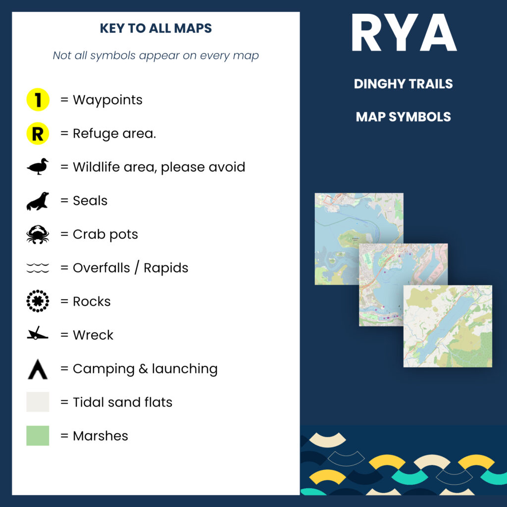
This map is for information use only, not for navigation.
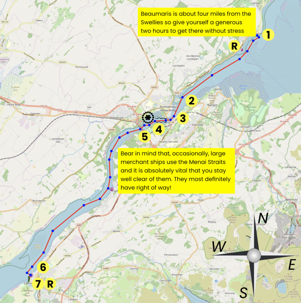
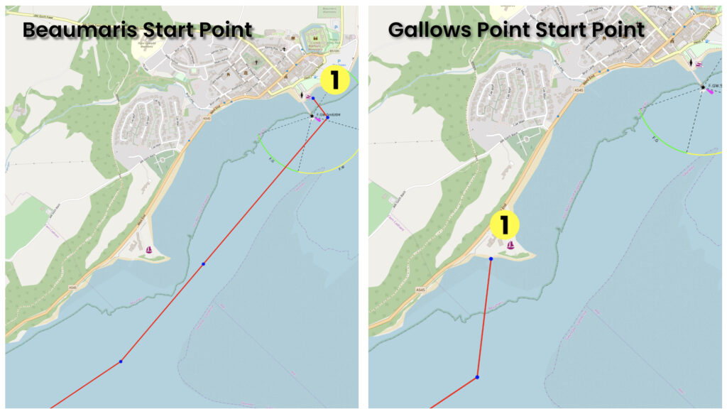
The Menai Straits GPX file is for the Beaumaris start point, if starting from Gallows Point, please disregard the first 5 waypoints on your chart plotter
For this trail, a craft with a secondary form of propulsion ( outboard ) that can cope with 6Kts of current is strongly advised
An extremely useful guide for transiting the straits can be found here.
This map is for information use only, not for navigation.
- Start at Beaumaris OR Gallows Point
- Sail past five islands close to the starboard shore; Ynys Big, Ynys Castell, Ynys Giant, Ynys Tobig and Ynys Faelog
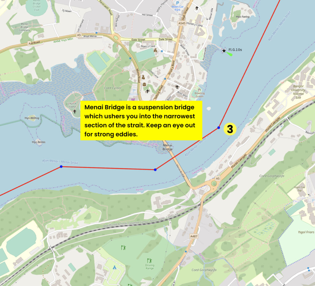
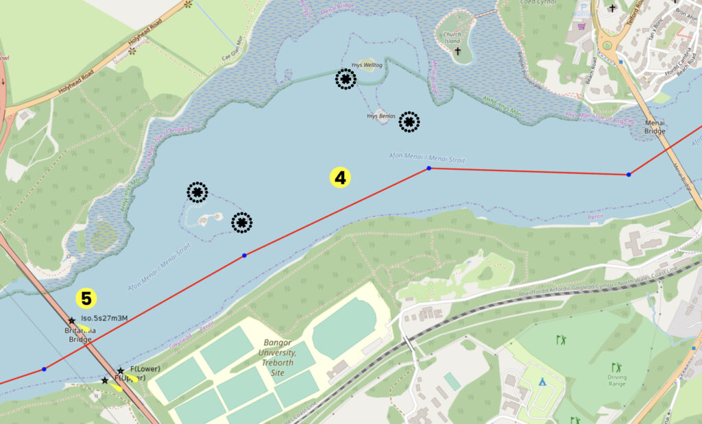
- You need to be at the Swellies at High Water Slack – This is 2 hours before HW Liverpool. This is the narrowest section of the Menai Straits and the tide can run through here at up to eight knots. Pass under the centre span of the Menai Suspension Bridge.
- Once under Menai Bridge, stick close to the Welsh side of the strait as North Swelly Platters, Cribbin and Britannia Rocks are menaces – although you have less to worry about in a dinghy. See this guide for a detailed guide on a safe passage.
- Pass through Britannia Railway Bridge and, all being well, you should now be able to carry a fair tide down to Caernarfon
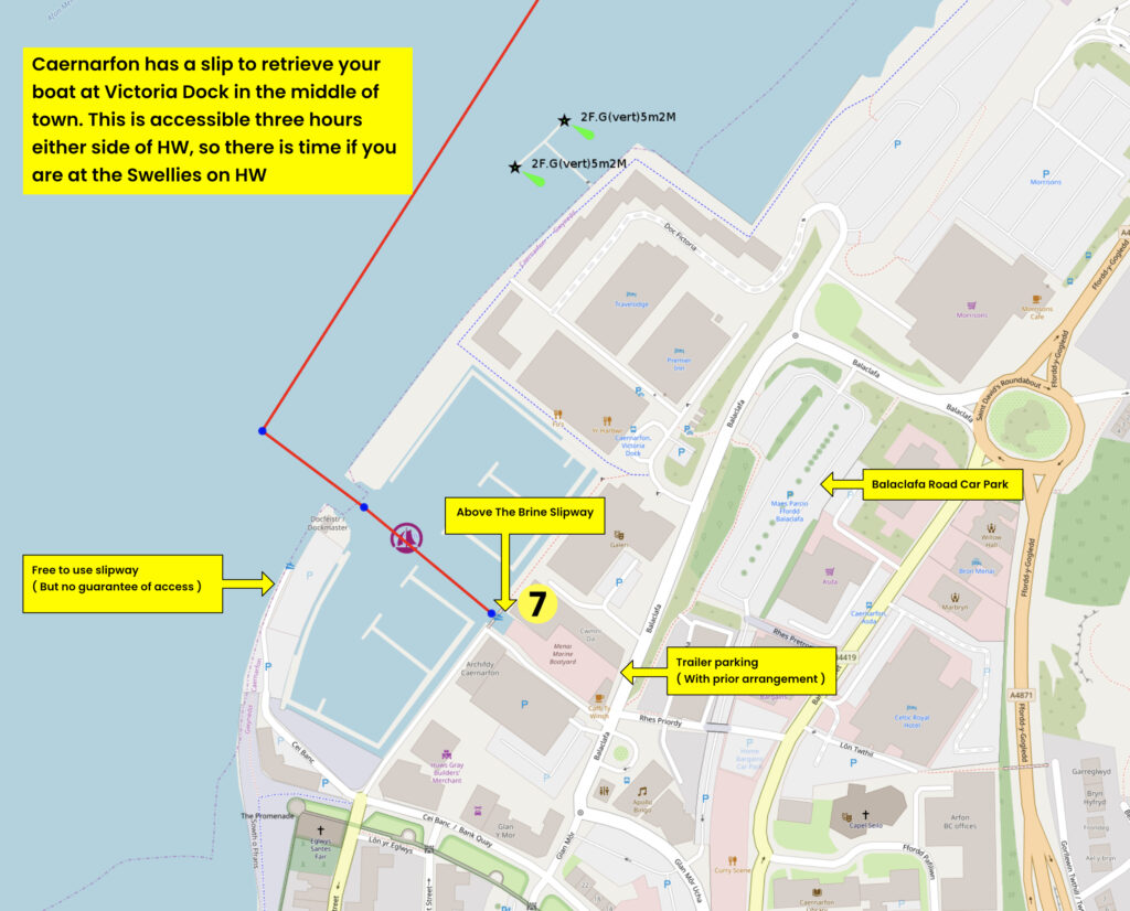
- Keep to Port as you approach Victoria Dock Marina, be ready to catch one of the visitor pontoons outside the marina entrance. You can drop sails here before going into the marina. Do call ahead on CH80
- Lower sails and motor or row/paddle into the marina and then towards the ‘Above The Brine’ slipway straight ahead. Call ahead on 01286 677 445
There is a free to use public slipway on the outside of the marine wall but his slipway may be blocked by vehicles and there is no guarantee that you can retrieve your craft
If using the Above The Brine slipway you will have to lower your mast before you continue up the slipway, there is a footbridge in the way!
This map is for information use only, not for navigation.
This map is for information use only, not for navigation.
This map is for information use only, not for navigation.
Contact Victoria Dock
Dock: 07483 072851 (operational hours only)
Email: dm@caernarfonharbour.org.uk
VHF: Channel 80
Harbour Office: 01286 875355 (08:00-16:00 Mon-Fri)
Contact Above The Brine
01286 677 445 or email boatyard@abovethebrine.com
Trip Extensions:
Anglesey is about much more than just the Menai Strait and the eastern side, exposed to the wild Irish Sea is a stunning and rugged place to visit with many fine coastal walks to enjoy interlaced with some charming villages. Ten things to do in Anglesey
Launch Point Lat and Long:
Beaumaris start point; 53°15’44.25″N – 4° 5’26.16″W
Gallows Point start point; 53°15’17.34″N – 4° 6’13.20″W
Launch Point What3Words:
Beaumaris; ///beginning.overdrive.secure
Gallows Point; ///ended.reef.noun
Launch Information:
For vessels without engines – Free (and small outboards and EV propulsion )
Tidal Information:
Set off 2 hours before HW to be at the Swellies on HW
Best Tides:
lunchtime high tide = 12,13,
Towing Vehicle Parking:
Park on the green at Beaumaris Green Car Park. ( If staying for the duration of your sail )
Park (temporarily) near the slipway while your boat is prepared for launching, then move your vehicle and trailer to the end of the trail.
Towing vehicle Parking What3Words:
If staying for the duration of your sail – ///aunts.octagonal.count
If moving to Caernarfon – ///cliff.test.divisions – THIS IS NOT A GUARANTEED PARKING PLACE ( The land is unclaimed and thus it is free, it gets very busy, especially in high season
Alternative parking at Balaclafa Rd Car Park ///hiking.moves.encounter
Towing vehicle Parking Information:
If parking at ///cliff.test.divisions the parking here is free, but there is no guarantee of getting a space
If parking at Balaclafa Rd or any other nearby car park (there are plenty) then £4.60 for 8 hours or £6.15 for 12 hours
Trailer Parking:
If using the slipway at ‘Above The Brine’ then with prior arrangement the trailer can be parked for £5 for the day. Contact Above The Bribe to make arrangements on 01286 677 445 or email boatyard@abovethebrine.com
Trailer Parking What3Words:
Balaclafa Rd Car Park ( you will need to pay for the trailer parking car park space ) ///hiking.moves.encounter
Above The Brine yard by prior arrangement ///heap.family.works
Trailer Parking Information:
£5 for the day at Above The Brine ( Where one of the slipways is located )
£6.15 for the day if using a car park space at Balaclafa Road Car Park
Toilets:
Yes
Toilets What3Words:
///spill.square.theme
Toilets Information:
Public toilets are at the end of Balaclafa Rd near the marina.
There are also toilets in numerous shopping and dining establishments within walking distance of the marina
Page Month Published: November 2025
Dinghy Trail Sponsor: