
Mission Statement: Explore one of Europe’s largest man-made reservoirs
Trail Introduction
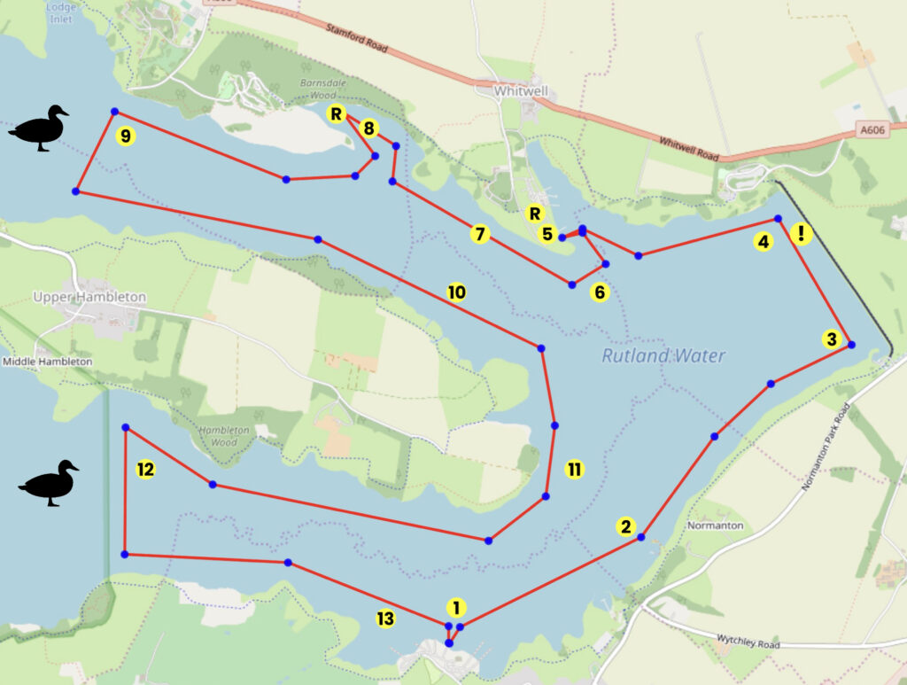
This trail takes an anti-clockwise route around this horseshoe-shaped lake, starting and finishing at Rutland Sailing Club. There is an optional stop off for refreshments at Whitwell on the north shore, where Rutland Watersports Centre also provides an alternative starting point for your cruise. With an extensive cruising area, an interesting shoreline and lots of wildlife, there is plenty to explore.
About the Area:
When the Gwash Valley in landlocked Rutland was flooded in the mid-1970s, England’s smallest county gained one of Europe’s largest and most beautiful man-made lakes.
Roughly the shape of a horseshoe, Rutland Water provides 3,000 acres to explore, complete with inlets, creeks and bays more usually associated with coastal sailing.
This provides lots of options for cruising sailors looking for a grand day out at this Anglian Water reservoir, whether it is an ice-cream run to Whitwell, sailing to the top of the northern leg, or dropping anchor in Barnsdale Creek for a picnic.
While Kielder Water in Northumberland is the UK’s biggest artificial lake by capacity, Rutland Water claims the title when measured by surface area.
Rutland Sailing Club was founded even before there was any water by enthusiasts who had spotted the potential for boating during the planning stages.
With its expanse of water, the club runs some of the largest events in the country, including the Tiger Trophy in memory of Olympic medallist and local hero John Merricks, which takes place in the depths of winter and is renowned for its hard sailing and hearty dinner in nearby Oakham.
When visiting, it is worth remembering that both Rutland SC and Rutland Watersports Centre offer relatively sheltered launching, and conditions may be much windier on the main lake.
The Hambleton Peninsula divides Rutland Water and when westerly winds blow straight down either arm of the reservoir, large waves can build up in the main sailing area towards the dam wall at the eastern end as there is a fetch of at least three miles.
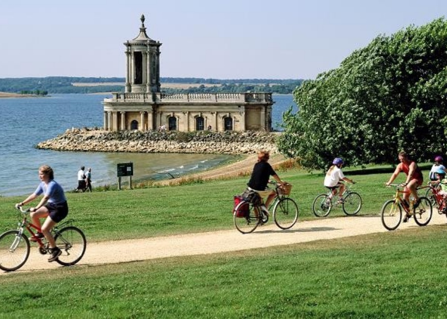
A fantastic viewpoint from which spectators can watch all the action on the water is Normanton Church on the South Shore, which is now a museum and wedding venue.
Visitors can also take in the sights from the Rutland Belle pleasure cruiser or by walking and cycling around the reservoir. The full trail around Rutland Water is 23 miles – or you can take a shortcut by skipping the peninsula for a 17-mile route!
Interesting fact:
Rutland Water is a haven not only for people but also for wildlife – including ospreys!
Thanks to the Rutland Osprey Project, which in 2001 celebrated the first osprey chick to fledge in central England for 150 years, the reservoir is now a great place for watching these magnificent birds of prey. Ospreys migrate from Africa to Rutland in spring so look out for them from April to September. Find out more: lrwt.org.uk/rutlandospreys
Round Trip Distance: 16km for the full trail, 10km for the shorter trail.
Approximate Time that the Trail will take: 4-8 hours
In a Wayfarer or similar in F4 winds
OS Map or Chart:OS 234
Trail Details
This map is for information use only, not for navigation.
- Launch from Rutland Sailing Club and head off in a north- easterly direction.
- Normanton Church is Rutland Water’s most famous landmark, providing an ideal backdrop for a selfie! Stay clear of the landing stage for the Rutland Belle pleasure cruiser.
- At the most easterly point of the lake is the Dam Wall with a view from here of both the north and south arm. Continue with the dam wall to your right, keeping 50m away.
- On the northern shore is Rutland Water Beach with a sandy shoreline cordoned off for paddling and swimming to provide an inland seaside!
- Sail into Whitwell Creek and watch the fun on the inflatables at Aqua Park Rutland! Stop off on the jetties at Rutland Watersports Centre for an ice cream or lunch. Report to the office after landing to let them know you are there, or stop on the beach in front of The Harbour Cafe.
- When leaving Whitwell Creek look out for Rutland Water Cruises on the right and the Rutland Belle, which takes sightseers across to Normanton on the South Shore. For a shorter cruise you could now head to Number 11.
- Head in a north- westerly direction into the north arm of Rutland Water with the reservoir’s north shore to your right.
- Barnsdale Creek is the only place where anchoring is allowed for cruising sailors on Rutland Water and provides a beautiful location for a break or a picnic.
- You are approaching the limit of the sailing area as this end of the north arm is reserved for wildlife. Now return eastwards to continue your cruise with the Hambleton Peninsula shoreline to your right.
- Continue past Upper Hambleton and along the shore of the peninsula which gives Rutland Water its distinctive horseshoe shape.
- At the tip of the peninsula keep the shoreline to your right to sail back into the south arm.
- Towards the buoys which mark the area reserved for wildlife, look out for ospreys fishing! This area of the lake is a hotspot in England for watching these magnificent birds of prey.
- Look out for boats and sailors, you are now nearly back at the club!
Safety Notices
No sailing area within fifty metres of the Dam or the Water Towers.
Do not moor up to racing or other buoys not specified for cruisers.
Feel free to sail up to, but not beyond the lines of buoys marking the nature reserves at both ends of the Western ends of the horseshoe shape.
Cruisers are not allowed to use inboard or outboard engines on Rutland Water; electric motors may be used on cruisers or tenders if required.
Trip Extensions:
Why not cycle around Rutland Water?
Launch Point Lat and Long: 52.64011983816946, -0.6406649030245829
Lat and Long for integration with the RYA “Find My Nearest” service
Launch Point What3Words: sunflower.buzz.exonerate
Launch Information:
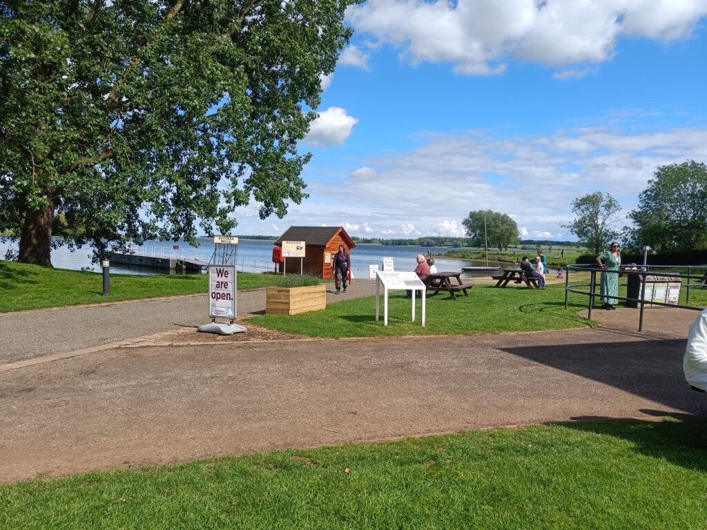
Rutland Sailing Club, LE15 8HJ. rutlandsailingclub.co.uk
Parking, launching, trailer storage and accommodation is available at the club. Please email sailing@rutlandsc.co.uk to book before arrival. Please book at least 24 hours prior to arrival.
Tidal Information: No tides
Towing Vehicle Parking: Onsite at the sailing club
Towing vehicle Parking: What3Words: sunflower.buzz.exonerate
Towing vehicle Parking Information: Part of the day permit payable at the sailing club
Trailer Parking: Onsite
Trailer Parking Information: As above
Trailer Parking What3Words: sunflower.buzz.exonerate
Toilets:
At the sailing club and at the cafe at The Harbour Cafe
Toilets What3Words: Sailing Club https://w3w.co/ambushes.jogged.likening
The Harbour Cafe https://w3w.co/skim.elsewhere.microchip
Page Month Published: March 2025
Dinghy Trail Sponsor: